![](/images/other/stat-length.png)
![Tocht Stappen Le Val-d'Ajol - Faymont 14,8km - Photo](https://media.geolcdn.com/t/1900/400/ext.pjpeg?maxdim=2&url=https%3A%2F%2Fservices.sitytrail.com%2FGeolivesWS%2FDownloadMedia.ashx%3FTrailID%3D655776%26Media%3Dfix__20161103111812.jpg)
Faymont 14,8km
DanielROLLET
Gebruiker
![Lengte](/images/other/stat-length.png)
Lengte
14,9 km
![Max. hoogte](https://static1.geolcdn.com/siteimages/upload/files/1508320355ic_sort_altitude_max_24dp.png)
Max. hoogte
584 m
![Positief hoogteverschil](https://static1.geolcdn.com/siteimages/upload/files/1508320355ic_sort_den_pos_24dp.png)
Positief hoogteverschil
458 m
![Km-Effort](/images/other/stat-length.png)
Km-Effort
21 km
![Min. hoogte](https://static1.geolcdn.com/siteimages/upload/files/1508320355ic_sort_altitude_min_24dp.png)
Min. hoogte
360 m
![Negatief hoogteverschil](https://static1.geolcdn.com/siteimages/upload/files/1508320355ic_sort_den_neg_24dp.png)
Negatief hoogteverschil
458 m
![Boucle](https://static1.geolcdn.com/siteimages/upload/files/16400158638029165_repeat_loop_refresh_sync_direction_icon.png)
Boucle
Ja
Datum van aanmaak :
2016-11-04 00:00:00.0
Laatste wijziging :
2016-11-04 00:00:00.0
![Stappen](https://static1.geolcdn.com/sitytour/trail-icons/101.png)
4h33
Moeilijkheid : Gemakkelijk
![Scan deze QR-code om de tocht te openen in de SityTrail-applicatie](https://capi.geolives.com/qq0zvz2zws4bq2lad0pu/sitytour/trails/655776/qr.png?size=200)
Gratisgps-wandelapplicatie
Over ons
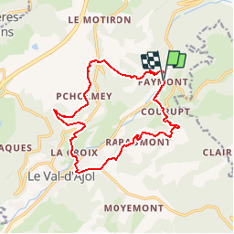
Tocht Stappen van 14,9 km beschikbaar op Grand Est, Vogezen, Le Val-d'Ajol. Deze tocht wordt voorgesteld door DanielROLLET.
Beschrijving
2016 11 03 11h15 à 17h30
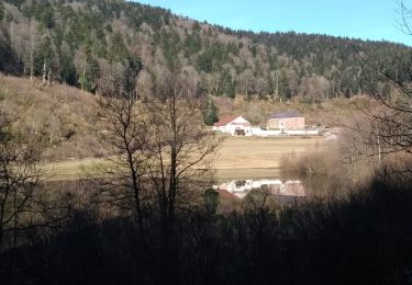
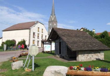
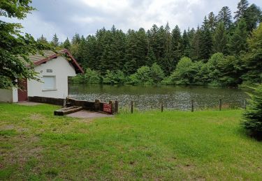
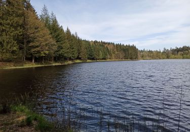
Ballade d'automne avec Marie, soleil, couleurs automne restau La résidence(déjeuner) De Buyer
Plaatsbepaling
Land:
France
Regio :
Grand Est
Departement/Provincie :
Vogezen
Gemeente :
Le Val-d'Ajol
Locatie:
Unknown
Vertrek:(Dec)
Vertrek:(UTM)
315002 ; 5313718 (32T) N.
Opmerkingen
Wandeltochten in de omgeving
![Tocht Te voet Girmont-Val-d'Ajol - Les Étangs du Girmont - Photo](https://media.geolcdn.com/t/375/260/ext.jpg?maxdim=2&url=https%3A%2F%2Fmedia.geolcdn.com%2Ff%2F5b2df71d-978f-45ae-8b89-c03378f2d860.jpeg)
![Te voet Te voet](https://static1.geolcdn.com/sitytour/trail-icons/100.png)
Les Étangs du Girmont
Te voet
Gemakkelijk
Girmont-Val-d'Ajol,
Grand Est,
Vogezen,
France
![](/images/other/stat-length.png)
9,9 km | 13,1 km-effort
2h 59min
![](https://static1.geolcdn.com/siteimages/upload/files/16400158638029165_repeat_loop_refresh_sync_direction_icon.png)
Ja
![Tocht Mountainbike Girmont-Val-d'Ajol - Rando de Che No 2013 - Photo](https://media.geolcdn.com/t/375/260/ext.jpg?maxdim=2&url=https%3A%2F%2Fstatic1.geolcdn.com%2Fsiteimages%2Fupload%2Ffiles%2F1524743154velo.jpg)
![Mountainbike Mountainbike](https://static1.geolcdn.com/sitytour/trail-icons/202.png)
Rando de Che No 2013
Mountainbike
Moeilijk
(1)
Girmont-Val-d'Ajol,
Grand Est,
Vogezen,
France
![](/images/other/stat-length.png)
48 km | 63 km-effort
3h 59min
![](https://static1.geolcdn.com/siteimages/upload/files/16400158638029165_repeat_loop_refresh_sync_direction_icon.png)
Ja
![Tocht Stappen La Montagne - la montagne 70000 - Photo](https://media.geolcdn.com/t/375/260/ext.jpg?maxdim=2&url=https%3A%2F%2Fmedia.geolcdn.com%2Ff%2F14a55937-fdd9-43ce-b4ae-5478c59489e1.jpg)
![Stappen Stappen](https://static1.geolcdn.com/sitytour/trail-icons/101.png)
la montagne 70000
Stappen
Zeer moeilijk
La Montagne,
Bourgondië-Franche-Comté,
Haute-Saône,
France
![](/images/other/stat-length.png)
17,2 km | 23 km-effort
5h 3min
![](https://static1.geolcdn.com/siteimages/upload/files/16400158638029165_repeat_loop_refresh_sync_direction_icon.png)
Neen
![Tocht Stappen Girmont-Val-d'Ajol - 24-02-19 girmont - Photo](https://media.geolcdn.com/t/375/260/ext.jpg?maxdim=2&url=https%3A%2F%2Fservices.sitytrail.com%2FGeolivesWS%2FDownloadMedia.ashx%3FTrailID%3D1115683%26Media%3Dfix__20190224152844.jpg)
![Stappen Stappen](https://static1.geolcdn.com/sitytour/trail-icons/101.png)
24-02-19 girmont
Stappen
Medium
Girmont-Val-d'Ajol,
Grand Est,
Vogezen,
France
![](/images/other/stat-length.png)
10,8 km | 15,4 km-effort
2h 35min
![](https://static1.geolcdn.com/siteimages/upload/files/16400158638029165_repeat_loop_refresh_sync_direction_icon.png)
Ja
![Tocht Sneeuwschoenen La Montagne - raquettes st bresson 14-01-17 - Photo](https://media.geolcdn.com/t/375/260/ext.jpg?maxdim=2&url=https%3A%2F%2Fservices.sitytrail.com%2FGeolivesWS%2FDownloadMedia.ashx%3FTrailID%3D684393%26Media%3Dfix__20170114160616.jpg)
![Sneeuwschoenen Sneeuwschoenen](https://static1.geolcdn.com/sitytour/trail-icons/504.png)
raquettes st bresson 14-01-17
Sneeuwschoenen
Gemakkelijk
La Montagne,
Bourgondië-Franche-Comté,
Haute-Saône,
France
![](/images/other/stat-length.png)
4,6 km | 5,9 km-effort
1h 36min
![](https://static1.geolcdn.com/siteimages/upload/files/16400158638029165_repeat_loop_refresh_sync_direction_icon.png)
Ja
![Tocht Stappen Girmont-Val-d'Ajol - Les Sources du Rey - Girmont Val d'Ajol - Photo](https://media.geolcdn.com/t/375/260/ext.jpg?maxdim=2&url=https%3A%2F%2Fservices.sitytrail.com%2FGeolivesWS%2FDownloadMedia.ashx%3FTrailID%3D109896%26Media%3D4903_5.jpg)
![Stappen Stappen](https://static1.geolcdn.com/sitytour/trail-icons/101.png)
Les Sources du Rey - Girmont Val d'Ajol
Stappen
Moeilijk
Girmont-Val-d'Ajol,
Grand Est,
Vogezen,
France
![](/images/other/stat-length.png)
13,3 km | 18,5 km-effort
4h 0min
![](https://static1.geolcdn.com/siteimages/upload/files/16400158638029165_repeat_loop_refresh_sync_direction_icon.png)
Ja
![Tocht Stappen Girmont-Val-d'Ajol - Circuit étangs, la Vigotte, La Racine, Girmont Val dAjol - Photo](https://media.geolcdn.com/t/375/260/ext.jpg?maxdim=2&url=https%3A%2F%2Fmedia.geolcdn.com%2Ff%2F55978459-befe-4c16-b8c5-b90eeb4e0126.jpg)
![Stappen Stappen](https://static1.geolcdn.com/sitytour/trail-icons/101.png)
Circuit étangs, la Vigotte, La Racine, Girmont Val dAjol
Stappen
Medium
Girmont-Val-d'Ajol,
Grand Est,
Vogezen,
France
![](/images/other/stat-length.png)
9,9 km | 13,6 km-effort
2h 30min
![](https://static1.geolcdn.com/siteimages/upload/files/16400158638029165_repeat_loop_refresh_sync_direction_icon.png)
Ja
![Tocht Stappen Le Val-d'Ajol - circuit chalet de l'empereur - la vigotte - Photo](https://media.geolcdn.com/t/375/260/ext.jpg?maxdim=2&url=https%3A%2F%2Fmedia.geolcdn.com%2Ff%2F49381514-f5b8-4280-a06f-1eedbaecec68.jpg)
![Stappen Stappen](https://static1.geolcdn.com/sitytour/trail-icons/101.png)
circuit chalet de l'empereur - la vigotte
Stappen
Moeilijk
Le Val-d'Ajol,
Grand Est,
Vogezen,
France
![](/images/other/stat-length.png)
11,5 km | 15,7 km-effort
2h 58min
![](https://static1.geolcdn.com/siteimages/upload/files/16400158638029165_repeat_loop_refresh_sync_direction_icon.png)
Ja
![Tocht Stappen La Montagne - 01-05-24 St Bresson - Photo](https://media.geolcdn.com/t/375/260/ext.jpg?maxdim=2&url=https%3A%2F%2Fmedia.geolcdn.com%2Ff%2Fc7bb1dd3-429c-4514-91cb-39f983c099b8.jpg)
![Stappen Stappen](https://static1.geolcdn.com/sitytour/trail-icons/101.png)
01-05-24 St Bresson
Stappen
Gemakkelijk
La Montagne,
Bourgondië-Franche-Comté,
Haute-Saône,
France
![](/images/other/stat-length.png)
7,2 km | 9,4 km-effort
1h 46min
![](https://static1.geolcdn.com/siteimages/upload/files/16400158638029165_repeat_loop_refresh_sync_direction_icon.png)
Ja